
Jilotepec topographic map
Interactive map
Click on the map to display elevation.
About this map
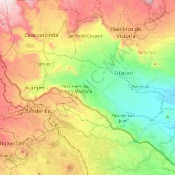
Name: Jilotepec topographic map, elevation, terrain.
Location: Jilotepec, Veracruz, Mexico (19.57862 -96.98782 19.64367 -96.84145)
Average elevation: 1,357 m
Minimum elevation: 809 m
Maximum elevation: 2,038 m
Other topographic maps
Click on a map to view its topography, its elevation and its terrain.
La Malinche
Mexico > Veracruz > Coatepec > Pacho Viejo > La Malinche
La Malinche, Pacho Viejo, Coatepec, Veracruz, 91602, Mexico
Average elevation: 1,193 m
El Satélite
Mexico > Veracruz > El Satélite
El Satélite, Las Choapas, Veracruz, Mexico
Average elevation: 317 m
Camino Real
Camino Real, Terrenos del Lote Tancoco, Tancoco, Veracruz, Mexico
Average elevation: 534 m
El Vizcaíno
Mexico > Veracruz > El Vizcaíno
El Vizcaíno, Coatzintla, Veracruz, Mexico
Average elevation: 123 m
Volcán San Martín
Volcán San Martín, San Andrés Tuxtla, Veracruz, Mexico
Average elevation: 1,322 m