
Thank you for supporting this site ❤️
Make a donation
Make a donation
Gear up for your next adventure:
As an Amazon Associate, this site earns from qualifying purchases at no extra cost to you.
Wenshui topographic map
Click on the map to display elevation.
Thank you for supporting this site ❤️
Make a donation
Make a donation
Gear up for your next adventure:
As an Amazon Associate, this site earns from qualifying purchases at no extra cost to you.
About this map
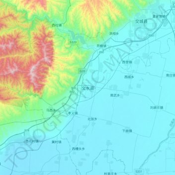
Name: Wenshui topographic map, elevation, terrain.
Location: Wenshui, Fengcheng, Wenshui County, Lüliang, Shanxi, China (37.27221 111.87054 37.59221 112.19054)
Average elevation: 906 m
Minimum elevation: 733 m
Maximum elevation: 1,870 m
Thank you for supporting this site ❤️
Make a donation
Make a donation
Gear up for your next adventure:
As an Amazon Associate, this site earns from qualifying purchases at no extra cost to you.