
Ogy topographic map
Interactive map
Click on the map to display elevation.
About this map
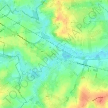
Name: Ogy topographic map, elevation, terrain.
Location: Ogy, Lessines, Ath, Hainaut, Wallonie, 7862, Belgique (50.70360 3.74512 50.73786 3.79892)
Average elevation: 38 m
Minimum elevation: 20 m
Maximum elevation: 64 m
Other topographic maps
Click on a map to view its topography, its elevation and its terrain.
Deux-Acren
Belgique > Hainaut > Ath > Lessines
Deux-Acren, Lessines, Ath, Hainaut, Wallonie, 7864, Belgique
Average elevation: 29 m
Bois-de-Lessines
Belgique > Hainaut > Ath > Lessines > Bois-de-Lessines
Bois-de-Lessines, Lessines, Ath, Hainaut, Wallonie, Belgique
Average elevation: 41 m