
Make a donation
Gear up for your next adventure:
As an Amazon Associate, this site earns from qualifying purchases at no extra cost to you.
Unternberg topographic map
Click on the map to display elevation.
Make a donation
Gear up for your next adventure:
As an Amazon Associate, this site earns from qualifying purchases at no extra cost to you.
Unternberg
Das Unternberg-Massiv ist die östliche Verlängerung des etwas höheren Eisenbergs (1490 m), von dem es durch die 1337 Meter hohe Einsattelung an der Unternbergalm abgetrennt wird. Der Bergstock wird im Süden von der Seetraun und im Osten von der Weißen Traun umflossen und begrenzt. Nach Norden fällt er in den Ruhpoldinger Talkessel ab. In Ostnordost-Richtung besitzt der Unternberg eine Erstreckung von 2,5 Kilometern. Seine Breite in Nord-Süd-Richtung beträgt maximal 2,2 Kilometer. Dem eigentlichen Bergstock sind im Norden kleinere Hügel vorgelagert, wie der 798 Meter hohe Menkenberg im Nordosten oder das 919 Meter hohe Boiderköpfl östlich von Weingarten.
Make a donation
Gear up for your next adventure:
As an Amazon Associate, this site earns from qualifying purchases at no extra cost to you.
About this map
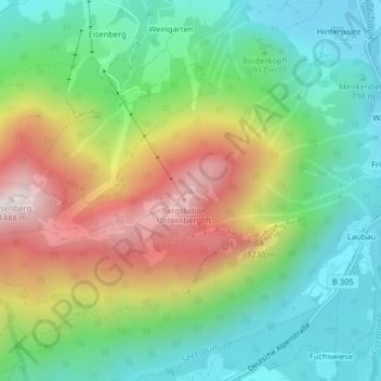
Name: Unternberg topographic map, elevation, terrain.
Average elevation: 960 m
Minimum elevation: 668 m
Maximum elevation: 1,452 m
Make a donation
Gear up for your next adventure:
As an Amazon Associate, this site earns from qualifying purchases at no extra cost to you.
Other topographic maps
Click on a map to view its topography, its elevation and its terrain.