Geolocate

Minera topographic map

Click on the map to display elevation.

About this map

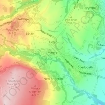
Name: Minera topographic map, elevation, terrain.

Location: Minera, Wrexham, Wales, LL11 3YU, United Kingdom (53.03958 -3.10472 53.07958 -3.06472)

Average elevation: 278 m

Minimum elevation: 138 m

Maximum elevation: 456 m

Other topographic maps

Click on a map to view its topography, its elevation and its terrain.

Gwersyllt

United Kingdom > Wales > Wrexham

Average elevation: 112 m

Penycae

United Kingdom > Wales > Wrexham

Average elevation: 350 m

Rhosddu

United Kingdom > Wales > Wrexham

Average elevation: 88 m

Bangor-on-Dee

United Kingdom > Wales > Wrexham

Average elevation: 30 m

Cefn

United Kingdom > Wales > Wrexham > Acrefair

Average elevation: 142 m

Gear up for your next adventure:

🪑Portable Backpacking Chairs - A comfortable seat for studying maps at the end of the day
🗺️Topographic Maps - Detailed maps for hiking and navigation
🧺Waterproof Dry Sacks - Organize your pack and keep electronics safe from rain and river crossings
🔭Compact Hiking Binoculars - Lightweight optics for scouting routes or birdwatching
🔌Fast Charging Adapters - Quickly top up all your gear before heading back into the field

As an Amazon Associate, this site earns from qualifying purchases at no extra cost to you.