
Make a donation
Gear up for your next adventure:
As an Amazon Associate, this site earns from qualifying purchases at no extra cost to you.
Traverse City topographic map
Click on the map to display elevation.
Make a donation
Gear up for your next adventure:
As an Amazon Associate, this site earns from qualifying purchases at no extra cost to you.
About this map
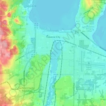
Name: Traverse City topographic map, elevation, terrain.
Average elevation: 204 m
Minimum elevation: 174 m
Maximum elevation: 307 m
Make a donation
Gear up for your next adventure:
As an Amazon Associate, this site earns from qualifying purchases at no extra cost to you.
Other topographic maps
Click on a map to view its topography, its elevation and its terrain.
Old Mission
United States > Michigan > Grand Traverse County
Old Mission is located just east of M-37 near the tip of Old Mission Peninsula about 16 miles (25.75 km) north of Traverse City. The community was built along Old Mission Harbor, which is a small safe haven along the East Arm of Grand Traverse Bay. The community sits at an elevation of 587 feet (179 m) above…
Average elevation: 190 m
Lookout Point
United States > Michigan > Grand Traverse County > Peninsula Township
Average elevation: 188 m
Diamond Park
United States > Michigan > Grand Traverse County > Green Lake Township
Average elevation: 255 m
Make a donation
Gear up for your next adventure:
As an Amazon Associate, this site earns from qualifying purchases at no extra cost to you.