Geolocate

Appleton topographic map

Click on the map to display elevation.

About this map

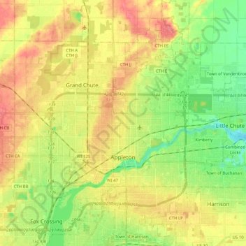
Name: Appleton topographic map, elevation, terrain.

Location: Appleton, Outagamie County, Wisconsin, United States (44.20866 -88.45158 44.35392 -88.34260)

Average elevation: 240 m

Minimum elevation: 206 m

Maximum elevation: 275 m

Gear up for your next adventure:

🍶Collapsible Water Bottles - Save space in your pack as you consume your water supply
🛌Compact Down Sleeping Bags - Warmth without the bulk, ideal for backcountry camping
🔪Camping Knives - Multi-purpose outdoor knives
📱Tablet Tripod Mounts - Steady platforms for viewing digital maps or taking long exposures
💧Personal Water Filters - Drink safely from streams and lakes identified on your map

As an Amazon Associate, this site earns from qualifying purchases at no extra cost to you.