
Cerro Mayor topographic map
Interactive map
Click on the map to display elevation.
About this map
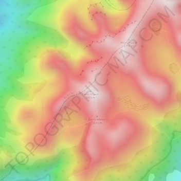
Name: Cerro Mayor topographic map, elevation, terrain.
Location: Cerro Mayor, Chíquiza, Centro, Boyacá, Colombia (5.69245 -73.43355 5.69255 -73.43345)
Average elevation: 3,537 m
Minimum elevation: 3,080 m
Maximum elevation: 3,790 m
Other topographic maps
Click on a map to view its topography, its elevation and its terrain.
San Pedro de Iguaque (Chíquiza)
Colombia > Boyacá > Chíquiza > San Pedro de Iguaque (Chíquiza)
San Pedro de Iguaque (Chíquiza), Chíquiza, Centro, Boyacá, Colombia
Average elevation: 2,990 m