Geolocate

Hart topographic map

Click on the map to display elevation.

About this map

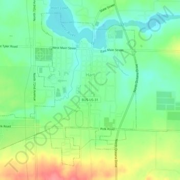
Name: Hart topographic map, elevation, terrain.

Location: Hart, Oceana County, Michigan, United States (43.68149 -86.39769 43.70963 -86.35223)

Average elevation: 215 m

Minimum elevation: 186 m

Maximum elevation: 263 m

Other topographic maps

Click on a map to view its topography, its elevation and its terrain.

Mears

United States > Michigan > Oceana County

Average elevation: 235 m

Gear up for your next adventure:

🧤Thermal Hiking Gloves - Keep your hands warm and functional during high-altitude winter treks
🐍Australian Snake Bite Kits - Specific pressure immobilization bandages for Australian venomous snakes
🪫Rechargeable Headlamps - USB rechargeable headlamps
🚗Car Camping Gear - Equipment for vehicle camping
👖Convertible Hiking Trousers - Zip-off legs to adapt to changing temperatures throughout the day

As an Amazon Associate, this site earns from qualifying purchases at no extra cost to you.