
North-East District topographic map
Interactive map
Click on the map to display elevation.
About this map
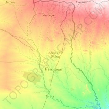
Name: North-East District topographic map, elevation, terrain.
Location: North-East District, Botswana (-21.56780 27.21458 -20.46804 28.01321)
Average elevation: 1,077 m
Minimum elevation: 846 m
Maximum elevation: 1,480 m
Most parts of Botswana have tableland slopes sliding from east to west. It is predominantly savannah, with tall grasses, bushes, and trees. The region has an average elevation of around 915 m (3,002 ft) above sea level. The annual precipitation is around 65 cm (26 in), most of which is received during the summer season from November to May. There are conflicts between agricultural expansion and the protection of indigenous wildlife within the Central District.
Other topographic maps
Click on a map to view its topography, its elevation and its terrain.
Molepolole
Molepolole, Kweneng District, Botswana
Average elevation: 1,143 m
Kalahari Desert
Kalahari Desert, Ghanzi District, Botswana
Average elevation: 1,168 m
Sheep Farm
Sheep Farm, Southern District, Botswana
Average elevation: 1,281 m
Moroka
Botswana > North-East District > Moroka
Moroka, North-East District, Botswana
Average elevation: 1,305 m
Maun
Botswana > North-West District > Maun
Maun, North-West District, P.O. BOX 217, Botswana
Average elevation: 942 m
Gaborone Dam
Botswana > South-East District > Gaborone
Gaborone Dam, Gaborone, South-East District, Botswana
Average elevation: 992 m
Okavango Delta
Botswana > North-West District
Okavango Delta, North-West District, Botswana
Average elevation: 955 m