
太平新城街道 topographic map
Interactive map
Click on the map to display elevation.
About this map
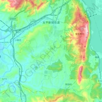
Name: 太平新城街道 topographic map, elevation, terrain.
Location: 太平新城街道, 安宁市, 云南省, 中国 (24.83935 102.52134 24.98286 102.62193)
Average elevation: 1,981 m
Minimum elevation: 1,832 m
Maximum elevation: 2,500 m
Other topographic maps
Click on a map to view its topography, its elevation and its terrain.