Geolocate

Salem topographic map

Click on the map to display elevation.

About this map

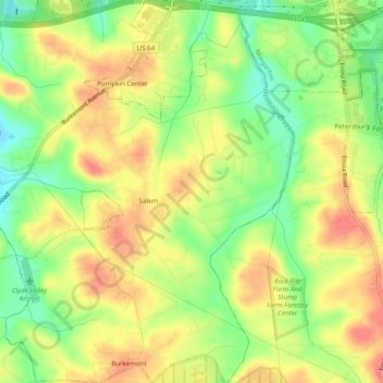
Name: Salem topographic map, elevation, terrain.

Location: Salem, Burke County, North Carolina, United States (35.67974 -81.72370 35.71957 -81.67841)

Average elevation: 358 m

Minimum elevation: 317 m

Maximum elevation: 395 m

Other topographic maps

Click on a map to view its topography, its elevation and its terrain.

Jonas Ridge

United States > North Carolina > Burke County

Average elevation: 1,136 m

Jonas Ridge

United States > North Carolina > Burke County

Average elevation: 1,136 m

Gold

United States > North Carolina > Burke County

Average elevation: 369 m

Linville

United States > North Carolina > Burke County

Average elevation: 412 m

Gear up for your next adventure:

🥾Trail Running Shoes - Shoes for trail running
🔪Outdoor Multi-tools - Versatile tools for gear repair and survival tasks in the wilderness
🖼️Scratch-off Australia Map - Track the regions and peaks you have explored geographically
🧤Thermal Hiking Gloves - Keep your hands warm and functional during high-altitude winter treks
🗺️Topographic Maps - Detailed maps for hiking and navigation

As an Amazon Associate, this site earns from qualifying purchases at no extra cost to you.