
Beverungen topographic map
Interactive map
Click on the map to display elevation.
About this map
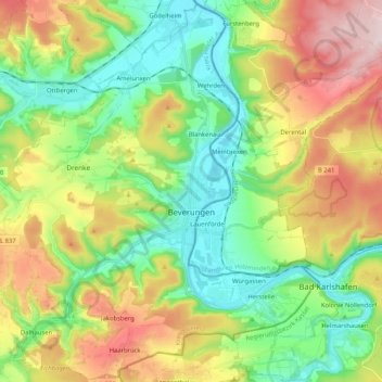
Name: Beverungen topographic map, elevation, terrain.
Location: Beverungen, Kreis Höxter, North Rhine-Westphalia, 37688, Germany (51.61117 9.23808 51.73774 9.44542)
Average elevation: 221 m
Minimum elevation: 88 m
Maximum elevation: 444 m
Other topographic maps
Click on a map to view its topography, its elevation and its terrain.
Warburg
Germany > North Rhine-Westphalia > Kreis Höxter
Warburg, Kreis Höxter, North Rhine-Westphalia, 34414, Germany
Average elevation: 248 m
Bad Driburg
Germany > North Rhine-Westphalia > Kreis Höxter
Bad Driburg, Kreis Höxter, North Rhine-Westphalia, 33014, Germany
Average elevation: 282 m
Neuenheerse
Germany > North Rhine-Westphalia > Kreis Höxter > Bad Driburg
Neuenheerse, Bad Driburg, Kreis Höxter, North Rhine-Westphalia, 33014, Germany
Average elevation: 328 m
Höxter
Germany > North Rhine-Westphalia > Kreis Höxter
Höxter, Kreis Höxter, North Rhine-Westphalia, 37671, Germany
Average elevation: 241 m
Steinheim
Germany > North Rhine-Westphalia > Kreis Höxter
Steinheim, Kreis Höxter, North Rhine-Westphalia, 32839, Germany
Average elevation: 200 m