
MacArthur topographic map
Interactive map
Click on the map to display elevation.
About this map
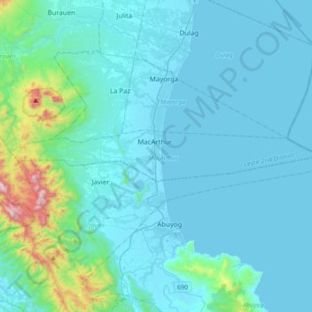
Name: MacArthur topographic map, elevation, terrain.
Average elevation: 110 m
Minimum elevation: -2 m
Maximum elevation: 1,122 m
Other topographic maps
Click on a map to view its topography, its elevation and its terrain.
Javier
Javier, Leyte 5th District, Leyte, Eastern Visayas, 6511, Philippines
Average elevation: 170 m
Colisao
Philippines > Leyte > Ormoc
Colisao, Ormoc, Leyte 4th District, Leyte, Eastern Visayas, 6541, Philippines
Average elevation: 24 m
Lima
Philippines > Leyte > Pastrana > Lima
Lima, Pastrana, Leyte 2nd District, Leyte, Eastern Visayas, 6514, Philippines
Average elevation: 36 m
MacArthur
Philippines > Leyte > MacArthur > MacArthur
MacArthur, Leyte 2nd District, Leyte, Eastern Visayas, 6509, Philippines
Average elevation: 6 m
Tabango
Philippines > Leyte > Tabango
Tabango, Leyte 3rd District, Leyte, Eastern Visayas, 6536, Philippines
Average elevation: 33 m
Tacloban
Philippines > Leyte > Tacloban
Tacloban, Leyte, Eastern Visayas, 6500, Philippines
Average elevation: 29 m
Dulag
Philippines > Leyte > Dulag
Dulag, Leyte 2nd District, Leyte, Eastern Visayas, 6505, Philippines
Average elevation: 3 m
Biasong
Philippines > Leyte > Biasong
Biasong, Baybay, Leyte 5th District, Leyte, Eastern Visayas, 6521, Philippines
Average elevation: 29 m