
Maestrazgo topographic map
Interactive map
Click on the map to display elevation.
About this map
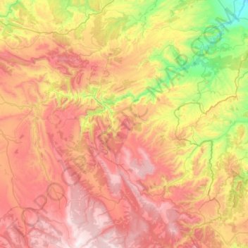
Name: Maestrazgo topographic map, elevation, terrain.
Location: Maestrazgo, Teruel, Aragon, Spain (40.42054 -0.78735 40.86256 -0.23357)
Average elevation: 1,194 m
Minimum elevation: 450 m
Maximum elevation: 1,964 m
Other topographic maps
Click on a map to view its topography, its elevation and its terrain.
Huesca
Spain > Aragon > Hoya de Huesca / Plana de Uesca
Huesca lies on a plateau in the northern region of Aragón, with an elevation of 488 m (1,601 ft) above sea level. Close to the city lie the Sierra de Guara mountains, which reach 2,077 m. The geographical coordinates of the city are: 42° 08´ N, 0° 24´ W.
Average elevation: 589 m