
Carantec topographic map
Click on the map to display elevation.
About this map
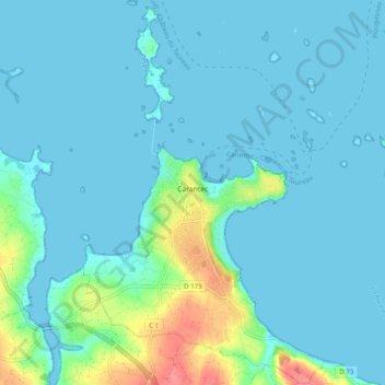
Name: Carantec topographic map, elevation, terrain.
Average elevation: 11 m
Minimum elevation: 0 m
Maximum elevation: 74 m
Other topographic maps
Click on a map to view its topography, its elevation and its terrain.
Lotissement Le Clos de Kersioual
France > Brittany > Finistère > Port-la-Forêt
Average elevation: 25 m
Manoir de Cœcilian (Saint-Pol-Roux)
France > Brittany > Finistère > Camaret-sur-Mer
Average elevation: 17 m