
Make a donation
Gear up for your next adventure:
As an Amazon Associate, this site earns from qualifying purchases at no extra cost to you.
Ferrick Mahamat Ousmane topographic map
Click on the map to display elevation.
Make a donation
Gear up for your next adventure:
As an Amazon Associate, this site earns from qualifying purchases at no extra cost to you.
About this map
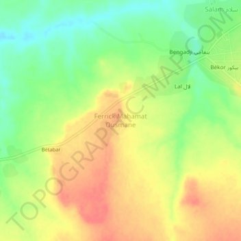
Name: Ferrick Mahamat Ousmane topographic map, elevation, terrain.
Location: Ferrick Mahamat Ousmane, Chad (7.84871 15.92877 7.88871 15.96877)
Average elevation: 499 m
Minimum elevation: 470 m
Maximum elevation: 524 m
Make a donation
Gear up for your next adventure:
As an Amazon Associate, this site earns from qualifying purchases at no extra cost to you.
Other topographic maps
Click on a map to view its topography, its elevation and its terrain.
Lake Chad
Lake Chad is divided into north and south parts by a natural dam, with the bottom of the northern basin at an altitude of 275.3 meters and the bottom of the southern basin at 278.2 meters. When the water level in the south exceeds 279 meters above sea level, it will flow into the north. In the south, there is…
Average elevation: 282 m