
Hoher Riffler topographic map
Interactive map
Click on the map to display elevation.
About this map
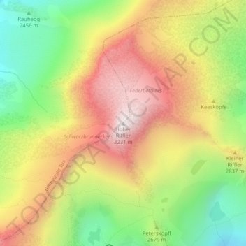
Name: Hoher Riffler topographic map, elevation, terrain.
Location: Hoher Riffler, Finkenberg, Schwaz, Tirol, A-6294, Österreich (47.08128 11.70428 47.08138 11.70438)
Average elevation: 2,720 m
Minimum elevation: 2,236 m
Maximum elevation: 3,205 m
Other topographic maps
Click on a map to view its topography, its elevation and its terrain.
Finkenberg
Österreich > Tirol > Finkenberg
Finkenberg, Bezirk Schwaz, Tirol, 6292, Österreich
Average elevation: 1,243 m