
Llansadwrn topographic map
Interactive map
Click on the map to display elevation.
About this map
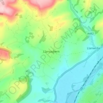
Name: Llansadwrn topographic map, elevation, terrain.
Location: Llansadwrn, Carmarthenshire, Wales, SA19 8LE, United Kingdom (51.94678 -3.92184 51.98678 -3.88184)
Average elevation: 120 m
Minimum elevation: 39 m
Maximum elevation: 311 m
Other topographic maps
Click on a map to view its topography, its elevation and its terrain.
Llandeilo
United Kingdom > Wales > Carmarthenshire
Llandeilo, Carmarthenshire, Wales, SA19 6EB, United Kingdom
Average elevation: 102 m
Pencader
United Kingdom > Wales > Carmarthenshire
Pencader, Carmarthenshire, Wales, SA39 9HF, United Kingdom
Average elevation: 182 m
Llanelli
United Kingdom > Wales > Carmarthenshire > Llanelli
Llanelli, Carmarthenshire, Wales, SA15 1SA, United Kingdom
Average elevation: 41 m
Login
United Kingdom > Wales > Carmarthenshire > Login
Login, Carmarthenshire, Wales, SA34 0XB, United Kingdom
Average elevation: 127 m
Llanybri
United Kingdom > Wales > Carmarthenshire
Llanybri, Carmarthenshire, Wales, SA33 5HF, United Kingdom
Average elevation: 67 m
Llansteffan
United Kingdom > Wales > Carmarthenshire
Llansteffan, Carmarthenshire, Wales, SA33 5JG, United Kingdom
Average elevation: 46 m