
Rivières topographic map
Interactive map
Click on the map to display elevation.
About this map
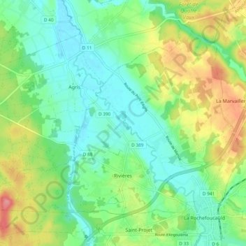
Name: Rivières topographic map, elevation, terrain.
Average elevation: 100 m
Minimum elevation: 69 m
Maximum elevation: 158 m
Other topographic maps
Click on a map to view its topography, its elevation and its terrain.
Grotte de la Ramisse
France > New Aquitaine > Rivières
Grotte de la Ramisse, Chemin du Moulin, Rivières, Angoulême, Charente, New Aquitaine, Metropolitan France, 16110, France
Average elevation: 94 m