Geolocate

Mount Bailey topographic map

Click on the map to display elevation.

About this map

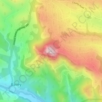
Name: Mount Bailey topographic map, elevation, terrain.

Location: Mount Bailey, Bailey, Park County, Colorado, United States (39.41522 -105.45977 39.41532 -105.45967)

Average elevation: 2,533 m

Minimum elevation: 2,349 m

Maximum elevation: 2,748 m

Gear up for your next adventure:

🧤Thermal Hiking Gloves - Keep your hands warm and functional during high-altitude winter treks
🪑Portable Backpacking Chairs - A comfortable seat for studying maps at the end of the day
🎨Portable Watercolor Kits - Paint the landscapes and topographic views you discover
👕UPF 50+ Sun Shirts - Essential protection against the harsh Australian sun during field work
🏫Topographic World Globes - 3D physical relief globes to understand global geography

As an Amazon Associate, this site earns from qualifying purchases at no extra cost to you.