
Make a donation
Gear up for your next adventure:
As an Amazon Associate, this site earns from qualifying purchases at no extra cost to you.
West Chester topographic map
Click on the map to display elevation.
Make a donation
Gear up for your next adventure:
As an Amazon Associate, this site earns from qualifying purchases at no extra cost to you.
About this map
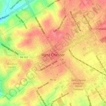
Name: West Chester topographic map, elevation, terrain.
Average elevation: 126 m
Minimum elevation: 78 m
Maximum elevation: 148 m
Make a donation
Gear up for your next adventure:
As an Amazon Associate, this site earns from qualifying purchases at no extra cost to you.
Other topographic maps
Click on a map to view its topography, its elevation and its terrain.
Strafford
United States > Pennsylvania > Chester County > Tredyffrin Township
Average elevation: 133 m
Longwood Gardens
United States > Pennsylvania > Chester County > East Marlborough Township
Average elevation: 125 m
Nottingham County Park
United States > Pennsylvania > Chester County > West Nottingham Township
Average elevation: 137 m
Valley Forge
United States > Pennsylvania > Chester County > Schuylkill Township
Average elevation: 78 m
Make a donation
Gear up for your next adventure:
As an Amazon Associate, this site earns from qualifying purchases at no extra cost to you.
Nottingham
United States > Pennsylvania > Chester County > West Nottingham Township
Average elevation: 145 m
Make a donation
Gear up for your next adventure:
As an Amazon Associate, this site earns from qualifying purchases at no extra cost to you.
East Nantmeal
United States > Pennsylvania > Chester County > East Nantmeal Township
Average elevation: 197 m
Freemont
United States > Pennsylvania > Chester County > West Nottingham Township
Average elevation: 115 m
Knickerbocker
United States > Pennsylvania > Chester County > Willistown Township
Average elevation: 127 m
Bondsville
United States > Pennsylvania > Chester County > East Brandywine Township
Average elevation: 150 m
Make a donation
Gear up for your next adventure:
As an Amazon Associate, this site earns from qualifying purchases at no extra cost to you.
Exton
United States > Pennsylvania > Chester County > West Whiteland Township
Average elevation: 125 m
Baptist Hill
United States > Pennsylvania > Chester County > Tredyffrin Township
Average elevation: 102 m
Saint Peters
United States > Pennsylvania > Chester County > Warwick Township
Average elevation: 157 m
Ship Road
United States > Pennsylvania > Chester County > West Whiteland Township > Exton
Average elevation: 133 m
Make a donation
Gear up for your next adventure:
As an Amazon Associate, this site earns from qualifying purchases at no extra cost to you.
Whitehorse
United States > Pennsylvania > Chester County > Willistown Township
Average elevation: 117 m
Reeceville
United States > Pennsylvania > Chester County > West Brandywine Township
Average elevation: 169 m
Make a donation
Gear up for your next adventure:
As an Amazon Associate, this site earns from qualifying purchases at no extra cost to you.
Baptism Creek Spring
United States > Pennsylvania > Chester County > North Coventry Township
Average elevation: 228 m
Barnsley
United States > Pennsylvania > Chester County > East Nottingham Township
Average elevation: 155 m
Copesville
United States > Pennsylvania > Chester County > East Bradford Township
Average elevation: 92 m
Make a donation
Gear up for your next adventure:
As an Amazon Associate, this site earns from qualifying purchases at no extra cost to you.
Valley Forge
United States > Pennsylvania > Chester County > Schuylkill Township
Average elevation: 78 m
Grove
United States > Pennsylvania > Chester County > West Whiteland Township
Average elevation: 128 m
Martins Corner
United States > Pennsylvania > Chester County > West Caln Township
Average elevation: 212 m
Paoli
United States > Pennsylvania > Chester County > Tredyffrin Township > Paoli
Average elevation: 128 m
Make a donation
Gear up for your next adventure:
As an Amazon Associate, this site earns from qualifying purchases at no extra cost to you.
Nottingham
United States > Pennsylvania > Chester County > West Nottingham Township > Nottingham
Average elevation: 145 m