
Sidossi topographic map
Interactive map
Click on the map to display elevation.
About this map
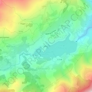
Name: Sidossi topographic map, elevation, terrain.
Average elevation: 942 m
Minimum elevation: 702 m
Maximum elevation: 1,415 m
Other topographic maps
Click on a map to view its topography, its elevation and its terrain.
Refuge de la Sega
France > Corse > Haute-Corse > Calacuccia
Refuge de la Sega, Mare à Mare Nord, Calacuccia, Corte, Haute-Corse, Corse, France métropolitaine, 20224, France
Average elevation: 1,390 m