
Río Casma topographic map
Interactive map
Click on the map to display elevation.
About this map
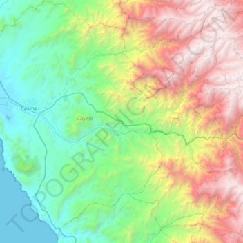
Name: Río Casma topographic map, elevation, terrain.
Location: Río Casma, Yaután, Casma, Áncash, Perú (-9.56770 -78.38166 -9.44675 -77.76041)
Average elevation: 1,529 m
Minimum elevation: 0 m
Maximum elevation: 4,921 m
Other topographic maps
Click on a map to view its topography, its elevation and its terrain.
Cerro Sechín
Cerro Sechín, Carretera Casma-Huaraz, Yaután, Casma, Áncash, Perú
Average elevation: 102 m