
Sacramento topographic map
Interactive map
Click on the map to display elevation.
About this map
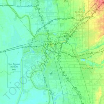
Name: Sacramento topographic map, elevation, terrain.
Average elevation: 10 m
Minimum elevation: -1 m
Maximum elevation: 51 m
Other topographic maps
Click on a map to view its topography, its elevation and its terrain.
Elk Grove
United States > California > Sacramento County
Elk Grove, Sacramento County, California, 95624, United States
Average elevation: 17 m
Brighton
United States > California > Sacramento County > Sacramento
Brighton, Sacramento, Sacramento County, CAL Fire Northern Region, California, 95819, United States
Average elevation: 14 m
American River
United States > California > Sacramento County > Rancho Cordova
American River, Rancho Cordova, Sacramento County, CAL Fire Northern Region, California, United States
Average elevation: 44 m
Polk
United States > California > Sacramento County > Sacramento
Polk, Sacramento, Sacramento County, CAL Fire Northern Region, California, 95826, United States
Average elevation: 13 m
Point Pleasant
United States > California > Sacramento County > Elk Grove
Point Pleasant, Elk Grove, Sacramento County, CAL Fire Northern Region, California, United States
Average elevation: 4 m
Fair Oaks
United States > California > Sacramento County
Fair Oaks, Sacramento County, CAL Fire Northern Region, California, 95628, United States
Average elevation: 55 m
Galt
United States > California > Sacramento County > Galt > Galt
Galt, Sacramento County, California, 95632, United States
Average elevation: 16 m
Vineyard
United States > California > Sacramento County > Elk Grove
Vineyard, Elk Grove, Sacramento County, California, 95829, United States
Average elevation: 21 m