
Make a donation
Gear up for your next adventure:
As an Amazon Associate, this site earns from qualifying purchases at no extra cost to you.
Favões topographic map
Click on the map to display elevation.
Make a donation
Gear up for your next adventure:
As an Amazon Associate, this site earns from qualifying purchases at no extra cost to you.
About this map
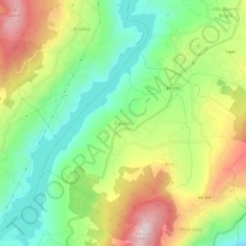
Name: Favões topographic map, elevation, terrain.
Average elevation: 206 m
Minimum elevation: 19 m
Maximum elevation: 471 m
Make a donation
Gear up for your next adventure:
As an Amazon Associate, this site earns from qualifying purchases at no extra cost to you.
Other topographic maps
Click on a map to view its topography, its elevation and its terrain.
Santo Tirso
The highest point in the municipality is in the Alto de S. Jorge, in the parish of Refojos, with 527 meters of altitude. The municipality's current perimeter is 69 kilometres (43 miles).
Average elevation: 185 m
Make a donation
Gear up for your next adventure:
As an Amazon Associate, this site earns from qualifying purchases at no extra cost to you.
Marco de Canaveses
The city of Marco Canaveses is strongly influenced by its topography, with mainly areas at altitudes between 200 and 600 meters, reaching the highest levels in Aboboreira and Montedeiras Mountains. The highest point of the county is situated at an altitude of 962 meters, in Aboboreira Mountain, which is shared…
Average elevation: 337 m
Make a donation
Gear up for your next adventure:
As an Amazon Associate, this site earns from qualifying purchases at no extra cost to you.
Make a donation
Gear up for your next adventure:
As an Amazon Associate, this site earns from qualifying purchases at no extra cost to you.
Make a donation
Gear up for your next adventure:
As an Amazon Associate, this site earns from qualifying purchases at no extra cost to you.
Make a donation
Gear up for your next adventure:
As an Amazon Associate, this site earns from qualifying purchases at no extra cost to you.
Make a donation
Gear up for your next adventure:
As an Amazon Associate, this site earns from qualifying purchases at no extra cost to you.
Make a donation
Gear up for your next adventure:
As an Amazon Associate, this site earns from qualifying purchases at no extra cost to you.
Vila Nova de Gaia
Vila Nova de Gaia is located on the southern bank at the mouth of the Douro River, directly across from the municipalities of Porto and Gondomar. In the west, the municipality extends towards the Atlantic Ocean, while in the east it includes the valleys of the Febros and Uíma [pt] rivers, tributaries of the…
Average elevation: 73 m
Matosinhos
At the end of the Bronze Age, settlements expanded into castros, proto-urban agglomerations at high altitudes. These existed in the northwestern regions of the Iberian Peninsula and predominated until the 1st century. Remnants of castros remain throughout the municipality, the most notable being Castro of…
Average elevation: 44 m
Make a donation
Gear up for your next adventure:
As an Amazon Associate, this site earns from qualifying purchases at no extra cost to you.
Make a donation
Gear up for your next adventure:
As an Amazon Associate, this site earns from qualifying purchases at no extra cost to you.
Make a donation
Gear up for your next adventure:
As an Amazon Associate, this site earns from qualifying purchases at no extra cost to you.
Matosinhos
At the end of the Bronze Age, much like most of the northwest peninsula, settlements expanded into proto-urban agglomerations at high altitudes (castros), associated with a culture with specific characteristics that predominated until the 1st century. Until today there still exist vestiges of castros dotting…
Average elevation: 44 m
Make a donation
Gear up for your next adventure:
As an Amazon Associate, this site earns from qualifying purchases at no extra cost to you.
Make a donation
Gear up for your next adventure:
As an Amazon Associate, this site earns from qualifying purchases at no extra cost to you.
Make a donation
Gear up for your next adventure:
As an Amazon Associate, this site earns from qualifying purchases at no extra cost to you.
Make a donation
Gear up for your next adventure:
As an Amazon Associate, this site earns from qualifying purchases at no extra cost to you.
Vila do Conde
The area of Vila do Conde is part of the granite-metamorphic basement, the Iberian Hercynian massif, that extends from the Spanish border to Espinho (15 km (9 mi) south of Porto). Over the Hercynian bedrock there is a prevalence of sandy beaches, and in other areas, the erosion of these sands has allowed the…
Average elevation: 29 m
Paços de Gaiolo
Portugal > Porto > Penhalonga e Paços de Gaiolo > Paços de Gaiolo
Average elevation: 274 m
Make a donation
Gear up for your next adventure:
As an Amazon Associate, this site earns from qualifying purchases at no extra cost to you.
Póvoa de Varzim
There are no full-days below freezing, yet temperatures below 0 °C (32.0 °F) can occur at the height of winter during the night and early morning. The city possesses a microclimate and is considered the region least subject to frosts in all northern Portugal. Cold waves are absent and snowfall is firmly…
Average elevation: 25 m
Make a donation
Gear up for your next adventure:
As an Amazon Associate, this site earns from qualifying purchases at no extra cost to you.