
Make a donation
Gear up for your next adventure:
As an Amazon Associate, this site earns from qualifying purchases at no extra cost to you.
Rioja topographic map
Click on the map to display elevation.
Make a donation
Gear up for your next adventure:
As an Amazon Associate, this site earns from qualifying purchases at no extra cost to you.
Rioja
The mountains in La Rioja are part of the Iberian System. This mountain range extends to the south of the Ebro river, parallel to it at a distance of about 40 to 60 km (25 to 37 miles), with altitudes ranging between 1,000 and 2,000 m (3,300 and 6,600 feet). From the mountain range the Sierra de la Demanda runs northwards, into the heart of La Rioja, incorporating Monte San Lorenzo which, at 2,271 m (7,451 ft), is the highest peak in the province. Other mountains include Sierra de Camero Viejo, Sierra de Camero Nuevo, Sierra de Cebollera, and Picos de Urbión.
Make a donation
Gear up for your next adventure:
As an Amazon Associate, this site earns from qualifying purchases at no extra cost to you.
About this map
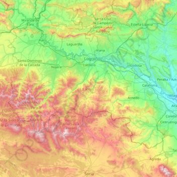
Name: Rioja topographic map, elevation, terrain.
Location: Rioja, Spain (41.91903 -3.13427 42.64426 -1.67870)
Average elevation: 873 m
Minimum elevation: 269 m
Maximum elevation: 2,298 m
Make a donation
Gear up for your next adventure:
As an Amazon Associate, this site earns from qualifying purchases at no extra cost to you.
Other topographic maps
Click on a map to view its topography, its elevation and its terrain.
Madrid
Spain > Community of Madrid > Área metropolitana de Madrid y Corredor del Henares > Madrid
Average elevation: 650 m
Make a donation
Gear up for your next adventure:
As an Amazon Associate, this site earns from qualifying purchases at no extra cost to you.
Huesca
Spain > Aragon > Hoya de Huesca / Plana de Uesca
Huesca lies on a plateau in the northern region of Aragón, with an elevation of 488 m (1,601 ft) above sea level. Close to the city lie the Sierra de Guara mountains, which reach 2,077 m. The geographical coordinates of the city are: 42° 08´ N, 0° 24´ W.
Average elevation: 589 m
Soil
Spain > Autonomous Community of the Basque Country > Montaña Alavesa/Arabako Mendialdea
Average elevation: 898 m
Alegranza Island
The area is 10.2 km². The island features a volcano with a crater of about 1.1 km in diameter and an altitude of 289 m. The second highest is Montaña de Lobos at 256 m and following La Rapagura. The northern portion is mainly flat.
Average elevation: 39 m
Make a donation
Gear up for your next adventure:
As an Amazon Associate, this site earns from qualifying purchases at no extra cost to you.
Make a donation
Gear up for your next adventure:
As an Amazon Associate, this site earns from qualifying purchases at no extra cost to you.
Make a donation
Gear up for your next adventure:
As an Amazon Associate, this site earns from qualifying purchases at no extra cost to you.
Park Beach
Spain > Andalusia > Costa del Sol Occidental > Estepona > Park Beach
Average elevation: 13 m
Make a donation
Gear up for your next adventure:
As an Amazon Associate, this site earns from qualifying purchases at no extra cost to you.
Caldes d'Estrac
Spain > Catalonia > Maresme > Caldes d'Estrac > Caldes d'Estrac
Average elevation: 57 m
Mijas
Spain > Andalusia > Costa del Sol Occidental > Mijas > Mijas
The climate changes gradually with increasing elevation in the mountains. Temperatures can drop to 10 °C (50 °F). In the peaks, over 600 m (2,000 ft) high, some ice may form in winter, while precipitation increases to almost 800 mm (32 in).
Average elevation: 447 m
Make a donation
Gear up for your next adventure:
As an Amazon Associate, this site earns from qualifying purchases at no extra cost to you.
Make a donation
Gear up for your next adventure:
As an Amazon Associate, this site earns from qualifying purchases at no extra cost to you.