
Lubbock topographic map
Click on the map to display elevation.
Lubbock
Summers are hot, with 78 afternoons on average of 90 °F (32.2 °C)+ highs and 7.4 afternoons of 100 °F (37.8 °C)+ highs, although due to the aridity and elevation, temperatures remain above 70 °F (21.1 °C) on only a few mornings. Lubbock is the 10th-windiest city in the US with an average wind speed of 12.4 mph (20.0 km/h; 5.5 m/s). The highest recorded temperature was 114 °F (45.6 °C) on June 27, 1994.
About this map
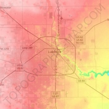
Name: Lubbock topographic map, elevation, terrain.
Location: Lubbock, Lubbock County, Texas, United States (33.44786 -102.03212 33.70843 -101.74901)
Average elevation: 983 m
Minimum elevation: 902 m
Maximum elevation: 1,015 m
Other topographic maps
Click on a map to view its topography, its elevation and its terrain.