
Thank you for supporting this site ❤️
Make a donation
Make a donation
Gear up for your next adventure:
As an Amazon Associate, this site earns from qualifying purchases at no extra cost to you.
Sofia topographic map
Click on the map to display elevation.
Thank you for supporting this site ❤️
Make a donation
Make a donation
Gear up for your next adventure:
As an Amazon Associate, this site earns from qualifying purchases at no extra cost to you.
About this map
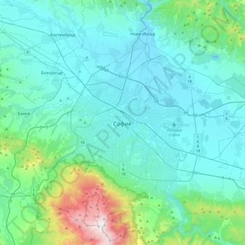
Name: Sofia topographic map, elevation, terrain.
Location: Sofia, Oborishte, Sofia City, Sofia-City, 1000, Bulgaria (42.53786 23.16218 42.85786 23.48218)
Average elevation: 754 m
Minimum elevation: 504 m
Maximum elevation: 2,279 m
Thank you for supporting this site ❤️
Make a donation
Make a donation
Gear up for your next adventure:
As an Amazon Associate, this site earns from qualifying purchases at no extra cost to you.