Geolocate

Clay Center topographic map

Click on the map to display elevation.

About this map

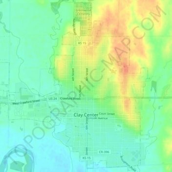
Name: Clay Center topographic map, elevation, terrain.

Location: Clay Center, Clay County, Kansas, United States (39.36493 -97.15521 39.40123 -97.10726)

Average elevation: 374 m

Minimum elevation: 358 m

Maximum elevation: 399 m

Gear up for your next adventure:

🌬️Windbreaker Jackets - Wind protection jackets
🎨Portable Watercolor Kits - Paint the landscapes and topographic views you discover
🎒Ultralight Backpacks - Lightweight packs for long hikes
📣High-Decibel Survival Whistles - Signaling tool for rescue that carries much further than a human voice
🔦Headlamps - Hands-free lighting for hiking

As an Amazon Associate, this site earns from qualifying purchases at no extra cost to you.