Geolocate

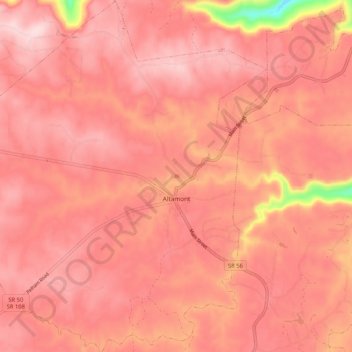
Altamont topographic map

Click on the map to display elevation.

Altamont

Altamont was established in 1848 as a county seat for Grundy County, which had been created in 1844. General Adrian Northcutt, a prominent local farmer and military officer, was the prime advocate for the site's selection. The town's name comes from combining alto (meaning "altitude") and mont (meaning "mountain"). Although the Civil War somewhat stunted the town's growth, by 1870 Altamont's population had grown to 217.

Wikipedia (CC-BY-SA 3.0)

About this map

Name: Altamont topographic map, elevation, terrain.

Location: Altamont, Grundy County, Middle Tennessee, Tennessee, 37349, United States (35.39240 -85.79076 35.47757 -85.69608)

Average elevation: 565 m

Minimum elevation: 368 m

Maximum elevation: 624 m

Other topographic maps

Click on a map to view its topography, its elevation and its terrain.
Pelham

United States > Tennessee > Grundy County

Average elevation: 320 m

Pelham

United States > Tennessee > Grundy County

Average elevation: 320 m

Gear up for your next adventure:

🔋Solar Power Banks - Charge your phone and GPS using the sun while deep in the bush
Outdoor Coffee Makers - Enjoy quality coffee at the summit of your favorite peak
🎒Tactical Waist Packs - Quick access to your compass, phone, and snacks while walking
📱Tablet Tripod Mounts - Steady platforms for viewing digital maps or taking long exposures
👖Convertible Hiking Trousers - Zip-off legs to adapt to changing temperatures throughout the day

As an Amazon Associate, this site earns from qualifying purchases at no extra cost to you.