
Os Vilares topographic map
Interactive map
Click on the map to display elevation.
About this map
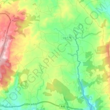
Name: Os Vilares topographic map, elevation, terrain.
Location: Os Vilares, Guitiriz, Tierra Chá, Lugo, Galicia, España (43.21109 -7.93648 43.26383 -7.79242)
Average elevation: 533 m
Minimum elevation: 420 m
Maximum elevation: 733 m
Other topographic maps
Click on a map to view its topography, its elevation and its terrain.
Piedrafita
España > Galicia > Tierra Chá > Guitiriz
Piedrafita, Guitiriz, Tierra Chá, Lugo, Galicia, 27389, España
Average elevation: 509 m