
Make a donation
Gear up for your next adventure:
As an Amazon Associate, this site earns from qualifying purchases at no extra cost to you.
Douglas topographic map
Click on the map to display elevation.
Make a donation
Gear up for your next adventure:
As an Amazon Associate, this site earns from qualifying purchases at no extra cost to you.
Douglas
Douglas has a record of its elevation above sea level of 1030.22 meters (3379.99 feet). Comparing Douglas district's yearly temperature to South Africa's averages, the records show that it is 4.01% higher with a temperature 25.23 °C (77.41 °F). Douglas is known for its Subtropical desert climate with 38.78 rainy days (10.62% of the time) and precipitation of about 19.31 millimeters (0.76 inches) annually.
Make a donation
Gear up for your next adventure:
As an Amazon Associate, this site earns from qualifying purchases at no extra cost to you.
About this map
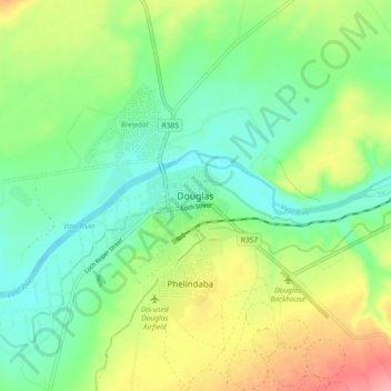
Name: Douglas topographic map, elevation, terrain.
Average elevation: 1,010 m
Minimum elevation: 975 m
Maximum elevation: 1,072 m
Make a donation
Gear up for your next adventure:
As an Amazon Associate, this site earns from qualifying purchases at no extra cost to you.
Other topographic maps
Click on a map to view its topography, its elevation and its terrain.
Mokala National Park
South Africa > Northern Cape > Pixley ka Seme District Municipality > Siyancuma Local Municipality
The Northern Cape is a dry region with fluctuating temperatures and differing topographies. The weather is typically that of desert and semi-desert areas. The annual rainfall is never high (between 300–500 mm, average 400 mm) and is always lower than the rate of evaporation. Summers (from December to…
Average elevation: 1,169 m
Boegoeberg Dam
South Africa > Northern Cape > Pixley ka Seme District Municipality > Siyancuma Local Municipality
Average elevation: 935 m