
Make a donation
Gear up for your next adventure:
As an Amazon Associate, this site earns from qualifying purchases at no extra cost to you.
Skokie topographic map
Click on the map to display elevation.
Make a donation
Gear up for your next adventure:
As an Amazon Associate, this site earns from qualifying purchases at no extra cost to you.
Skokie
The Chicago "L"s Yellow Line terminates at the Dempster Street station in Skokie. Construction has been completed on a new Yellow Line train station at Oakton Street, to serve downtown Skokie. It opened on April 30, 2012. Additionally, the CTA is commissioning an alternatives analysis study on the extension of the Yellow Line terminal to Old Orchard Road for Federal Transit Administration New Start grants. The New Starts program allows federal funds to be used for capital projects provided that all extensions for a given problem (i.e., enabling easy transportation for reverse commuters to Westfield Old Orchard) are considered. The extension recommended by the CTA, is the elevation of the Yellow Line to a new terminal south of Old Orchard Road. This extension was canceled.
Make a donation
Gear up for your next adventure:
As an Amazon Associate, this site earns from qualifying purchases at no extra cost to you.
About this map
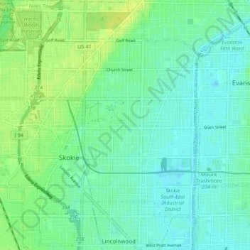
Name: Skokie topographic map, elevation, terrain.
Location: Skokie, Niles Township, Cook County, Illinois, United States (42.00455 -87.78088 42.06514 -87.70853)
Average elevation: 190 m
Minimum elevation: 181 m
Maximum elevation: 200 m
Make a donation
Gear up for your next adventure:
As an Amazon Associate, this site earns from qualifying purchases at no extra cost to you.
Other topographic maps
Click on a map to view its topography, its elevation and its terrain.
Make a donation
Gear up for your next adventure:
As an Amazon Associate, this site earns from qualifying purchases at no extra cost to you.
Make a donation
Gear up for your next adventure:
As an Amazon Associate, this site earns from qualifying purchases at no extra cost to you.
Make a donation
Gear up for your next adventure:
As an Amazon Associate, this site earns from qualifying purchases at no extra cost to you.
Make a donation
Gear up for your next adventure:
As an Amazon Associate, this site earns from qualifying purchases at no extra cost to you.
Make a donation
Gear up for your next adventure:
As an Amazon Associate, this site earns from qualifying purchases at no extra cost to you.
Chicago, North Shore & Milwaukee
United States > Illinois > Cook County > Northbrook > Williamsburg Square
Average elevation: 198 m
Make a donation
Gear up for your next adventure:
As an Amazon Associate, this site earns from qualifying purchases at no extra cost to you.
Elmwood Park
United States > Illinois > Cook County > Elmwood Park > Elmwood Park
Average elevation: 194 m
Make a donation
Gear up for your next adventure:
As an Amazon Associate, this site earns from qualifying purchases at no extra cost to you.
West Branch Du Page River
United States > Illinois > Cook County > Schaumburg
Average elevation: 249 m