
Glacier Point topographic map
Interactive map
Click on the map to display elevation.
About this map
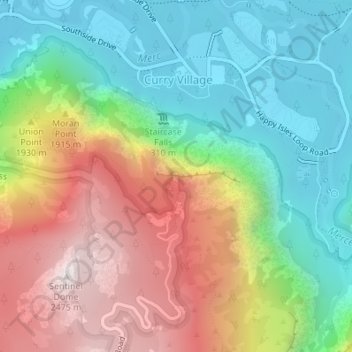
Name: Glacier Point topographic map, elevation, terrain.
Average elevation: 1,711 m
Minimum elevation: 1,204 m
Maximum elevation: 2,479 m
Glacier Point ist ein Aussichtspunkt oberhalb des Yosemite Valley, in Kalifornien, USA. Er liegt an der Südseite des Tales in einer Höhe von 2200 m über Normalnull und knapp 1000 m oberhalb von Curry Village. Von hier hat man eine überwältigende Aussicht über den Yosemite National Park und das Yosemite Valley, inklusive Yosemite Falls, Half Dome, Vernal Fall, Nevada Fall, und Clouds Rest.