
Calau topographic map
Interactive map
Click on the map to display elevation.
About this map
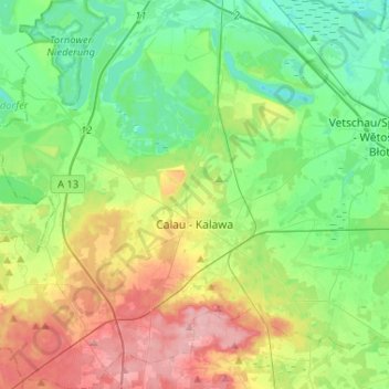
Name: Calau topographic map, elevation, terrain.
Location: Calau, Oberspreewald-Lausitz, Brandenburg, 03205, Deutschland (51.67841 13.79822 51.83892 14.05045)
Average elevation: 83 m
Minimum elevation: 43 m
Maximum elevation: 159 m
In Calau steht die Napoleoneiche mit einem Brusthöhenumfang von 7,30 m (2016).
Other topographic maps
Click on a map to view its topography, its elevation and its terrain.
Weißag
Deutschland > Brandenburg > Oberspreewald-Lausitz > Luckaitztal
Weißag, Luckaitztal, Altdöbern, Oberspreewald-Lausitz, Brandenburg, 03229, Deutschland
Average elevation: 127 m
Koßwig
Deutschland > Brandenburg > Oberspreewald-Lausitz > Vetschau/Spreewald
Koßwig, Vetschau/Spreewald, Oberspreewald-Lausitz, Brandenburg, Deutschland
Average elevation: 67 m
Senftenberg
Deutschland > Brandenburg > Oberspreewald-Lausitz
Senftenberg, Oberspreewald-Lausitz, Brandenburg, Deutschland
Average elevation: 110 m
Lübbenau/Spreewald
Deutschland > Brandenburg > Oberspreewald-Lausitz
Lübbenau/Spreewald, Oberspreewald-Lausitz, Brandenburg, 03222, Deutschland
Average elevation: 60 m
Hohenbocka
Deutschland > Brandenburg > Oberspreewald-Lausitz
Hohenbocka, Ruhland, Oberspreewald-Lausitz, Brandenburg, Deutschland
Average elevation: 126 m
Lauchhammer
Deutschland > Brandenburg > Oberspreewald-Lausitz > Lauchhammer
Lauchhammer, Oberspreewald-Lausitz, Brandenburg, 01979, Deutschland
Average elevation: 107 m