Geolocate

Luuk topographic map

Click on the map to display elevation.

About this map

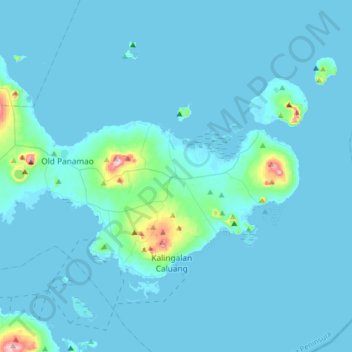
Name: Luuk topographic map, elevation, terrain.

Location: Luuk, Sulu, Zamboanga Peninsula, Philippines (5.80800 121.15353 6.12800 121.47353)

Average elevation: 22 m

Minimum elevation: -2 m

Maximum elevation: 407 m

Other topographic maps

Click on a map to view its topography, its elevation and its terrain.

Lugus Island

Philippines > Sulu

Average elevation: 20 m

Bambannan Island

Philippines > Sulu

Average elevation: 0 m

Dammi Island

Philippines > Sulu

Average elevation: 0 m

Lugus

Philippines > Sulu

Average elevation: 7 m

Siasi

Philippines > Sulu

Average elevation: 7 m

Seit Lake

Philippines > Sulu > Old Panamao

Average elevation: 14 m

North Ubian Island

Philippines > Sulu > Pangutaran

Average elevation: 2 m

Simisa Island

Philippines > Sulu > Banguingui

Average elevation: 2 m

Kulassian Island

Philippines > Sulu > Pangutaran

Average elevation: 0 m

Jolo Island

Philippines > Sulu

Average elevation: 28 m

Patikul

Philippines > Sulu

Average elevation: 50 m

Pangutaran

Philippines > Sulu

Average elevation: 4 m

Siasi Island

Philippines > Sulu > Siasi

Average elevation: 47 m

Siasi

Philippines > Sulu

Average elevation: 7 m

Gear up for your next adventure:

🛌Sleeping Mats - Insulated mats for camping comfort
🔪Multitools - Compact tools for outdoor use
🖼️Scratch-off Australia Map - Track the regions and peaks you have explored geographically
🦯Adjustable Trekking Poles - Reduce impact on knees when descending steep topographic ridges
📱Shockproof Phone Cases - Extra protection for your smartphone against drops on rocky terrain

As an Amazon Associate, this site earns from qualifying purchases at no extra cost to you.