
Salzburg Süd topographic map
Interactive map
Click on the map to display elevation.
About this map
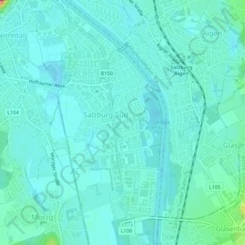
Name: Salzburg Süd topographic map, elevation, terrain.
Location: Salzburg Süd, Salzburg, 5020, Österreich (47.76788 13.05963 47.79532 13.07618)
Average elevation: 428 m
Minimum elevation: 414 m
Maximum elevation: 507 m
Other topographic maps
Click on a map to view its topography, its elevation and its terrain.
Schloss Freisaal
Österreich > Salzburg > Salzburg
Schloss Freisaal, Freisaalweg, Nonntal, Salzburg, 5020, Österreich
Average elevation: 429 m
Schloss Emslieb
Österreich > Salzburg > Salzburg
Schloss Emslieb, Hellbrunner Allee, Morzg, Salzburg, 5020, Österreich
Average elevation: 433 m
Schloss Mirabell
Österreich > Salzburg > Salzburg
Schloss Mirabell, Bernhard-Paumgartner-Weg, Neustadt, Salzburg, 5020, Österreich
Average elevation: 438 m
Schloss Aigen
Österreich > Salzburg > Salzburg
Schloss Aigen, Schwarzenbergpromenade, Aigen, Salzburg, 5020, Österreich
Average elevation: 522 m