
Make a donation
Gear up for your next adventure:
As an Amazon Associate, this site earns from qualifying purchases at no extra cost to you.
Es Corrals topographic map
Click on the map to display elevation.
Make a donation
Gear up for your next adventure:
As an Amazon Associate, this site earns from qualifying purchases at no extra cost to you.
About this map
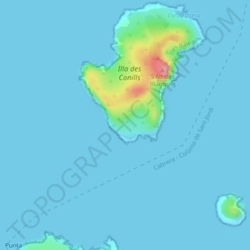
Name: Es Corrals topographic map, elevation, terrain.
Location: Es Corrals, Balearic Islands, Spain (39.16723 2.95178 39.18723 2.97178)
Average elevation: 8 m
Minimum elevation: 0 m
Maximum elevation: 114 m
Make a donation
Gear up for your next adventure:
As an Amazon Associate, this site earns from qualifying purchases at no extra cost to you.
Other topographic maps
Click on a map to view its topography, its elevation and its terrain.
Majorca
Mallorca and the other Balearic Islands are geologically an extension of the fold mountains of the Betic Cordillera of Andalusia. They consist primarily of sediments deposited in the Tethys Sea during the Mesozoic era. These marine deposits have given rise to calcareous rocks which are often fossiliferous. The…
Average elevation: 61 m
Palma
Spain > Balearic Islands > Palma
Palma is a major city and seaport located in the southwest of Mallorca, a western Mediterranean island belonging to the Balearic Islands archipelago. The land area of the city is about 21.355 square kilometres (8.245 sq mi) with an altitude of 13 metres (43 feet) above sea level.
Average elevation: 49 m
Majorca
Mallorca and the other Balearic Islands are geologically an extension of the fold mountains of the Betic Cordillera of Andalusia. They consist primarily of sediments deposited in the Tethys Sea during the Mesozoic era. These marine deposits have given rise to calcareous rocks which are often fossiliferous. The…
Average elevation: 57 m
Make a donation
Gear up for your next adventure:
As an Amazon Associate, this site earns from qualifying purchases at no extra cost to you.
Majorca
Mallorca and the other Balearic Islands are geologically an extension of the fold mountains of the Betic Cordillera of Andalusia. They consist primarily of sediments deposited in the Tethys Sea during the Mesozoic era. These marine deposits have given rise to calcareous rocks which are often fossiliferous. The…
Average elevation: 57 m
Palma de Mallorca
Spain > Balearic Islands > Palma
Palma is a major city and seaport located in the southwest of Mallorca, a western Mediterranean island belonging to the Balearic Islands archipelago. The land area of the city is about 21.355 square kilometres (8.245 sq mi) with an altitude of 13 metres (43 feet) above sea level.
Average elevation: 49 m
Make a donation
Gear up for your next adventure:
As an Amazon Associate, this site earns from qualifying purchases at no extra cost to you.
Palma de Mallorca
Spain > Balearic Islands > Palma
Palma is a major city and seaport located in the southwest of Mallorca, a western Mediterranean island belonging to the Balearic Islands archipelago. The land area of the city is about 21.355 square kilometres (8.245 sq mi) with an altitude of 13 metres (43 feet) above sea level.
Average elevation: 49 m
Serra de Tramuntana
Spain > Balearic Islands > Serra de Tramuntana
The climate in the Tramuntana Range is significantly wetter than the rest of the island, recording as much as 1507 mm (59.3 inches) of precipitation per year, in comparison with some other parts of the island where annual rainfall is less than 400mm (15 inch). It is also cooler due to the altitude, and a few…
Average elevation: 175 m
Paseo Marítimo de la Bahia de Sant Antoni de Portmany
Spain > Balearic Islands > Ibiza > Sant Antoni de Portmany
Average elevation: 11 m
Make a donation
Gear up for your next adventure:
As an Amazon Associate, this site earns from qualifying purchases at no extra cost to you.
Serra de Tramuntana
Spain > Balearic Islands > Serra de Tramuntana
The climate in the Tramuntana Range is significantly wetter than the rest of the island, recording as much as 1507 mm (59.3 inches) of precipitation per year, in comparison with some other parts of the island where annual rainfall is less than 400mm (15 inch). It is also cooler due to the altitude, and a few…
Average elevation: 175 m
Make a donation
Gear up for your next adventure:
As an Amazon Associate, this site earns from qualifying purchases at no extra cost to you.
Palma
Palma is a major city and seaport located in the southwest of Mallorca, a western Mediterranean island belonging to the Balearic Islands archipelago. The land area of the city is about 21.355 square kilometres (8.245 sq mi) with an altitude of 13 metres (43 feet) above sea level.
Average elevation: 49 m
Make a donation
Gear up for your next adventure:
As an Amazon Associate, this site earns from qualifying purchases at no extra cost to you.
Palma de Mallorca
Spain > Balearic Islands > Palma
Palma is a major city and seaport located in the southwest of Mallorca, a western Mediterranean island belonging to the Balearic Islands archipelago. The land area of the city is about 21.355 square kilometres (8.245 sq mi) with an altitude of 13 metres (43 feet) above sea level.
Average elevation: 45 m
Majorca
Mallorca and the other Balearic Islands are geologically an extension of the fold mountains of the Betic Cordillera of Andalusia. They consist primarily of sediments deposited in the Tethys Sea during the Mesozoic era. These marine deposits have given rise to calcareous rocks which are often fossiliferous. The…
Average elevation: 57 m
Make a donation
Gear up for your next adventure:
As an Amazon Associate, this site earns from qualifying purchases at no extra cost to you.
Make a donation
Gear up for your next adventure:
As an Amazon Associate, this site earns from qualifying purchases at no extra cost to you.
Make a donation
Gear up for your next adventure:
As an Amazon Associate, this site earns from qualifying purchases at no extra cost to you.
Make a donation
Gear up for your next adventure:
As an Amazon Associate, this site earns from qualifying purchases at no extra cost to you.
Majorca
Mallorca and the other Balearic Islands are geologically an extension of the fold mountains of the Betic Cordillera of Andalusia. They consist primarily of sediments deposited in the Tethys Sea during the Mesozoic era. These marine deposits have given rise to calcareous rocks which are often fossiliferous. The…
Average elevation: 57 m
Make a donation
Gear up for your next adventure:
As an Amazon Associate, this site earns from qualifying purchases at no extra cost to you.
Make a donation
Gear up for your next adventure:
As an Amazon Associate, this site earns from qualifying purchases at no extra cost to you.
Majorca
Mallorca and the other Balearic Islands are geologically an extension of the fold mountains of the Betic Cordillera of Andalusia. They consist primarily of sediments deposited in the Tethys Sea during the Mesozoic era. These marine deposits have given rise to calcareous rocks which are often fossiliferous. The…
Average elevation: 57 m
Make a donation
Gear up for your next adventure:
As an Amazon Associate, this site earns from qualifying purchases at no extra cost to you.
Cala Grassio
Spain > Balearic Islands > Ibiza > Sant Antoni de Portmany > Can Germà > Cap Negret
Average elevation: 23 m
Make a donation
Gear up for your next adventure:
As an Amazon Associate, this site earns from qualifying purchases at no extra cost to you.
Calvià
Spain > Balearic Islands > Serra de Tramuntana
Calvià first appears in history as a village 2,000 years BCE, although the area was first populated in the Neolithic Era. Later, sailors coming from the east stopped in the Balearics on their way to the Iberian Peninsula, where they sought metals. They came from Italy, from other Mediterranean islands, and…
Average elevation: 134 m
Palma
Palma is a major city and seaport located in the southwest of Mallorca, a western Mediterranean island belonging to the Balearic Islands archipelago. The land area of the city is about 21.355 square kilometres (8.245 sq mi) with an altitude of 13 metres (43 feet) above sea level.
Average elevation: 45 m
Make a donation
Gear up for your next adventure:
As an Amazon Associate, this site earns from qualifying purchases at no extra cost to you.
Make a donation
Gear up for your next adventure:
As an Amazon Associate, this site earns from qualifying purchases at no extra cost to you.
Serra de Tramuntana
Spain > Balearic Islands > Serra de Tramuntana
The climate in the Tramuntana Range is significantly wetter than the rest of the island, recording as much as 1507 mm (59.3 inches) of precipitation per year, in comparison with some other parts of the island where annual rainfall is less than 400mm (15 inch). It is also cooler due to the altitude, and a few…
Average elevation: 175 m
Make a donation
Gear up for your next adventure:
As an Amazon Associate, this site earns from qualifying purchases at no extra cost to you.
Make a donation
Gear up for your next adventure:
As an Amazon Associate, this site earns from qualifying purchases at no extra cost to you.
Make a donation
Gear up for your next adventure:
As an Amazon Associate, this site earns from qualifying purchases at no extra cost to you.