
Make a donation
Gear up for your next adventure:
As an Amazon Associate, this site earns from qualifying purchases at no extra cost to you.
Zgorzelec County topographic map
Click on the map to display elevation.
Make a donation
Gear up for your next adventure:
As an Amazon Associate, this site earns from qualifying purchases at no extra cost to you.
About this map
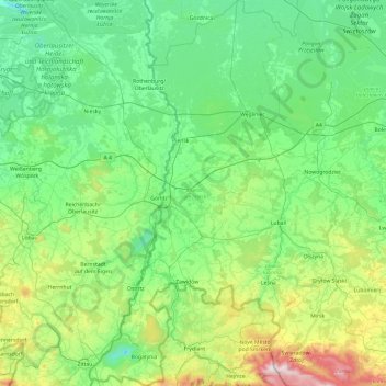
Name: Zgorzelec County topographic map, elevation, terrain.
Location: Zgorzelec County, Lower Silesian Voivodeship, Poland (50.86193 14.81737 51.46403 15.33992)
Average elevation: 259 m
Minimum elevation: 48 m
Maximum elevation: 1,123 m
Make a donation
Gear up for your next adventure:
As an Amazon Associate, this site earns from qualifying purchases at no extra cost to you.
Other topographic maps
Click on a map to view its topography, its elevation and its terrain.
Śnieżka / Sněžka
Poland > Lower Silesian Voivodeship > Karkonosze County > Karpacz
Due to high altitude the climate is maritime polar (Köppen: ET) not far from a continental subpolar climate (Dfc). The difference should be at least 6 °C lower on annual average compared to the weather station in the plains.
Average elevation: 1,263 m
Sudety
Poland > Lower Silesian Voivodeship > Ząbkowice Śląskie County > Starczówek
Average elevation: 293 m
Make a donation
Gear up for your next adventure:
As an Amazon Associate, this site earns from qualifying purchases at no extra cost to you.
Szary Kamień
Poland > Lower Silesian Voivodeship > Kłodzko County > Lądek-Zdrój
Average elevation: 492 m
Polanica
Poland > Lower Silesian Voivodeship > Ząbkowice Śląskie County > Nowina
Average elevation: 247 m
Make a donation
Gear up for your next adventure:
As an Amazon Associate, this site earns from qualifying purchases at no extra cost to you.
Jelenia Góra
Poland > Lower Silesian Voivodeship > Jelenia Góra > Jelenia Góra
Average elevation: 515 m
Make a donation
Gear up for your next adventure:
As an Amazon Associate, this site earns from qualifying purchases at no extra cost to you.
Szklana Góra
Poland > Lower Silesian Voivodeship > Zgorzelec County > Stary Węgliniec
Average elevation: 214 m
Make a donation
Gear up for your next adventure:
As an Amazon Associate, this site earns from qualifying purchases at no extra cost to you.