
Make a donation
Gear up for your next adventure:
As an Amazon Associate, this site earns from qualifying purchases at no extra cost to you.
Tarhuna topographic map
Click on the map to display elevation.
Make a donation
Gear up for your next adventure:
As an Amazon Associate, this site earns from qualifying purchases at no extra cost to you.
Tarhuna
During the late 1950s and into the 1960s, the RAF established a bombing range on the outskirts of the town. It was manned by RAF personnel from nearby RAF Idris and it was used by Canberra bombers from various bases in Germany. The range consisted of a main control tower with full equipment for communication with the bomber crews, at 45 degrees to the left was a quadrant tower to cross reference the plotting of the bomb hits, to convey the strike position of each bomb, and a target constructed out of 45 gallon oil drums, filled with concrete and built into a pyramid approximately 40-50 feet high and painted white. The range was used to practice the art of a new manouvre known as LABS (low altitude bombing system), where the bomb is launched in a lob towards the target, so that by the time the bomb hits the target, the aircraft has retreated at high altitude and at high speed.
Make a donation
Gear up for your next adventure:
As an Amazon Associate, this site earns from qualifying purchases at no extra cost to you.
About this map
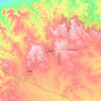
Name: Tarhuna topographic map, elevation, terrain.
Location: Tarhuna, Murqub, Libya (32.27459 13.47507 32.59459 13.79507)
Average elevation: 360 m
Minimum elevation: 135 m
Maximum elevation: 513 m
Make a donation
Gear up for your next adventure:
As an Amazon Associate, this site earns from qualifying purchases at no extra cost to you.