
Thank you for supporting this site ❤️
Make a donation
Make a donation
Gear up for your next adventure:
🛰️Handheld GPS Units - Rugged GPS devices for tracking coordinates and elevation in the Australian bush
As an Amazon Associate, this site earns from qualifying purchases at no extra cost to you.
Driebergen-Rijsenburg topographic map
Click on the map to display elevation.
Thank you for supporting this site ❤️
Make a donation
Make a donation
Gear up for your next adventure:
As an Amazon Associate, this site earns from qualifying purchases at no extra cost to you.
About this map
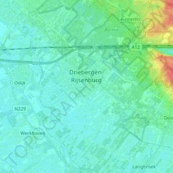
Name: Driebergen-Rijsenburg topographic map, elevation, terrain.
Location: Driebergen-Rijsenburg, Utrechtse Heuvelrug, Utrecht, Netherlands (52.00835 5.24699 52.08657 5.34173)
Average elevation: 8 m
Minimum elevation: 0 m
Maximum elevation: 48 m
Thank you for supporting this site ❤️
Make a donation
Make a donation
Gear up for your next adventure:
🧭Global Orienteering Compass - High-precision liquid-filled compasses for accurate map reading and navigation
As an Amazon Associate, this site earns from qualifying purchases at no extra cost to you.
Other topographic maps
Click on a map to view its topography, its elevation and its terrain.
Thank you for supporting this site ❤️
Make a donation
Make a donation
Gear up for your next adventure:
As an Amazon Associate, this site earns from qualifying purchases at no extra cost to you.