Geolocate

Barrie topographic map

Click on the map to display elevation.

About this map

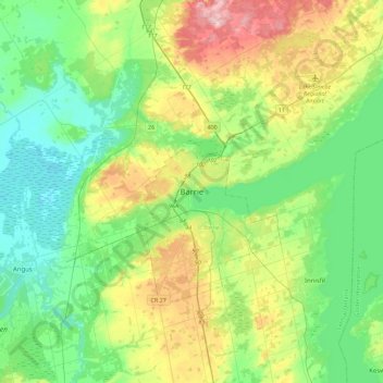
Name: Barrie topographic map, elevation, terrain.

Location: Barrie, Ontario, L4M 1A3, Canada (44.22934 -79.85017 44.54934 -79.53017)

Average elevation: 248 m

Minimum elevation: 178 m

Maximum elevation: 412 m

Other topographic maps

Click on a map to view its topography, its elevation and its terrain.

Kempenfelt Bay

Canada > Ontario > Barrie

Average elevation: 228 m

Sunnidale Park

Canada > Ontario > Barrie

Average elevation: 266 m

Bunker's Creek

Canada > Ontario > Barrie

Average elevation: 233 m

Hickling Park

Canada > Ontario > Barrie

Average elevation: 256 m

Gear up for your next adventure:

🦯Adjustable Trekking Poles - Reduce impact on knees when descending steep topographic ridges
🧦Hiking Socks - Comfortable socks for long hikes
👄SPF Lip Balm - Prevent sun and wind-burnt lips on mountain ridges
🦟Heavy Duty Insect Repellent - Essential protection against flies, mozzies, and march flies
🔋Rechargeable Batteries - Eco-friendly power for high-drain GPS units and flashlights

As an Amazon Associate, this site earns from qualifying purchases at no extra cost to you.