Geolocate

Magnet Cove topographic map

Click on the map to display elevation.

About this map
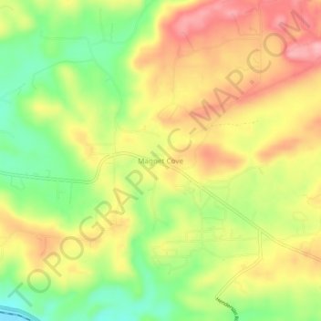
Name: Magnet Cove topographic map, elevation, terrain.

Location: Magnet Cove, Hot Spring County, Arkansas, 72105, United States (34.43426 -92.86461 34.47426 -92.82461)

Average elevation: 156 m

Minimum elevation: 82 m

Maximum elevation: 223 m

Other topographic maps

Click on a map to view its topography, its elevation and its terrain.
Malvern

United States > Arkansas > Hot Spring County

Average elevation: 101 m

Malvern

United States > Arkansas > Hot Spring County

Average elevation: 101 m

Gear up for your next adventure:

📕Australia Maps - Maps covering Australian regions
📸Action Cameras - Record your journey across interesting topographic features in 4K
🎒Dry Bags - Waterproof bags for outdoor gear
🧳Outdoor Travel Organizers - Gear organization accessories
🕶️Polarized Outdoor Sunglasses - Reduce glare from rocks and water for better visual navigation

As an Amazon Associate, this site earns from qualifying purchases at no extra cost to you.