
Make a donation
Gear up for your next adventure:
As an Amazon Associate, this site earns from qualifying purchases at no extra cost to you.
Trobriand Islands topographic map
Click on the map to display elevation.
Make a donation
Gear up for your next adventure:
As an Amazon Associate, this site earns from qualifying purchases at no extra cost to you.
Trobriand Islands
The Trobriands consist of four main islands, the largest being Kiriwina Island, and the others being Kaileuna, Vakuta and Kitava. Kiriwina is 43 kilometres (27 miles) long, and varies in width from 1 to 16 kilometres (0.62 to 9.94 mi). In the 1980s, there were around sixty villages on the island, containing around 12,000 people, while the other islands were restricted to a population of hundreds. Other than some elevation on Kiriwina, the islands are flat coral atolls and "remain hot and humid throughout the year, with frequent rainfall."
Make a donation
Gear up for your next adventure:
As an Amazon Associate, this site earns from qualifying purchases at no extra cost to you.
About this map
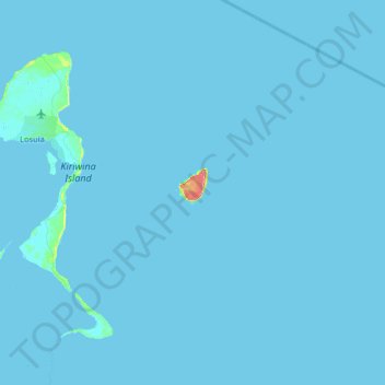
Name: Trobriand Islands topographic map, elevation, terrain.
Average elevation: 1 m
Minimum elevation: -1 m
Maximum elevation: 92 m
Make a donation
Gear up for your next adventure:
As an Amazon Associate, this site earns from qualifying purchases at no extra cost to you.
Other topographic maps
Click on a map to view its topography, its elevation and its terrain.
Make a donation
Gear up for your next adventure:
As an Amazon Associate, this site earns from qualifying purchases at no extra cost to you.