
Leebrug topographic map
Interactive map
Click on the map to display elevation.
About this map
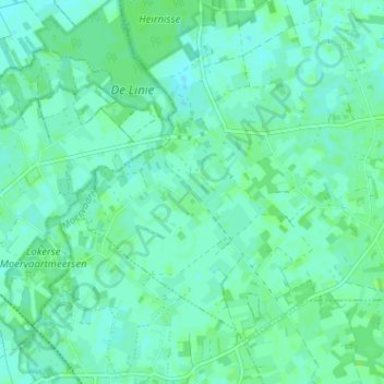
Name: Leebrug topographic map, elevation, terrain.
Location: Leebrug, Sinaai, Sint-Niklaas, Oost-Vlaanderen, 9112, België (51.12984 3.98362 51.16984 4.02362)
Average elevation: 4 m
Minimum elevation: 0 m
Maximum elevation: 7 m
Other topographic maps
Click on a map to view its topography, its elevation and its terrain.
Molenhoek
België > Oost-Vlaanderen > Sint-Niklaas > Sint-Niklaas > Sinaai
Molenhoek, Sinaai, Sint-Niklaas, Oost-Vlaanderen, Vlaanderen, 9112, België
Average elevation: 6 m
Kwaadhoek
België > Oost-Vlaanderen > Sint-Niklaas > Sint-Niklaas > Sinaai > Kwaadhoek
Kwaadhoek, Sinaai, Sint-Niklaas, Oost-Vlaanderen, Vlaanderen, 9112, België
Average elevation: 5 m