
Lac Meilleur topographic map
Interactive map
Click on the map to display elevation.
About this map
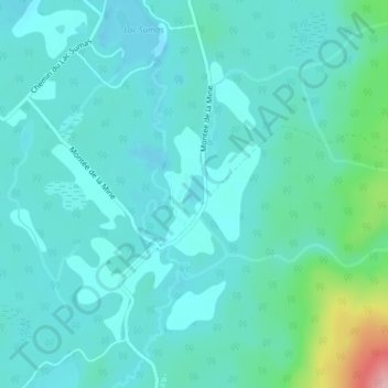
Name: Lac Meilleur topographic map, elevation, terrain.
Average elevation: 275 m
Minimum elevation: 249 m
Maximum elevation: 407 m
Other topographic maps
Click on a map to view its topography, its elevation and its terrain.
Lac McCaskill
Canada > Québec > Antoine-Labelle > L'Ascension
Lac McCaskill, L'Ascension, Antoine-Labelle, Laurentides, Québec, Canada
Average elevation: 331 m
Lac Durand
Canada > Québec > Antoine-Labelle > L'Ascension
Lac Durand, L'Ascension, Antoine-Labelle, Laurentides, Québec, Canada
Average elevation: 338 m