Geolocate

Wakefield topographic map

Click on the map to display elevation.

About this map

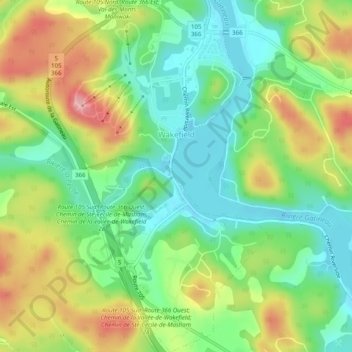
Name: Wakefield topographic map, elevation, terrain.

Location: Wakefield, La Pêche, Les Collines-de-l'Outaouais, Outaouais, Quebec, Canada (45.61854 -75.94520 45.65314 -75.91626)

Average elevation: 151 m

Minimum elevation: 94 m

Maximum elevation: 238 m

Other topographic maps

Click on a map to view its topography, its elevation and its terrain.

Alcove

Canada > Quebec > Les Collines-de-l'Outaouais > La Pêche

Average elevation: 141 m

Rupert

Canada > Quebec > Les Collines-de-l'Outaouais > La Pêche

Average elevation: 187 m

Duclos

Canada > Quebec > Les Collines-de-l'Outaouais > La Pêche

Average elevation: 195 m

Gear up for your next adventure:

👄SPF Lip Balm - Prevent sun and wind-burnt lips on mountain ridges
🎽Base Layers - Thermal base layers
🧴SPF 50+ Bulk Sunscreen - Maximum protection for long-term outdoor exposure
🔦Powerful LED Headlamps - Hands-free lighting for night navigation and setting up camp after dark
🧤Thermal Hiking Gloves - Keep your hands warm and functional during high-altitude winter treks

As an Amazon Associate, this site earns from qualifying purchases at no extra cost to you.