
Thank you for supporting this site ❤️
Make a donation
Make a donation
Gear up for your next adventure:
As an Amazon Associate, this site earns from qualifying purchases at no extra cost to you.
Beatrice topographic map
Click on the map to display elevation.
Thank you for supporting this site ❤️
Make a donation
Make a donation
Gear up for your next adventure:
As an Amazon Associate, this site earns from qualifying purchases at no extra cost to you.
About this map
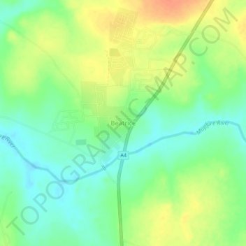
Name: Beatrice topographic map, elevation, terrain.
Location: Beatrice, Seke, Mashonaland East Province, Zimbabwe (-18.27809 30.83441 -18.23809 30.87441)
Average elevation: 1,297 m
Minimum elevation: 1,278 m
Maximum elevation: 1,320 m
Thank you for supporting this site ❤️
Make a donation
Make a donation
Gear up for your next adventure:
As an Amazon Associate, this site earns from qualifying purchases at no extra cost to you.