
Cité Soleil topographic map
Interactive map
Click on the map to display elevation.
About this map
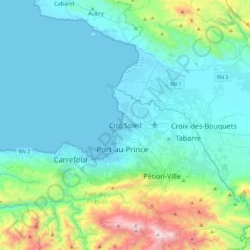
Name: Cité Soleil topographic map, elevation, terrain.
Location: Cité Soleil, Port-au-Prince, West, 6130, Haiti (18.41828 -72.49560 18.73828 -72.17560)
Average elevation: 321 m
Minimum elevation: 0 m
Maximum elevation: 1,919 m
Other topographic maps
Click on a map to view its topography, its elevation and its terrain.
Pity
Haiti > West > Commune Léogâne
Pity, Commune Léogâne, Arrondissement de Léogâne, West, Haiti
Average elevation: 6 m